ΣΥΝΤΟΜΗ ΠΕΡΙΓΡΑΦΗ
Καλοκαιρινός Όλυμπος και ανάβαση στο Σχολιό , τη δεύτερη ψηλότερη κορφή του μυθικού βουνού. Και μην νομίζετε ότι έχει ζέστη .Υπολογίστε ότι για κάθε 250μ ,η θερμοκρασία μειώνεται κατά 2 περίπου βαθμούς. Σε συνδυασμό και με τον αέρα που μπορεί να φυσάει ή τη νέφωση, μπορεί να κάνει και κρύο. Άρα φροντίστε και για κανένα μπουφανάκι.
ΧΡΗΣΙΜΕΣ ΠΛΗΡΟΦΟΡΙΕΣ
Απόσταση από Θεσ/νικη 153 km
Ευρωπαϊκός Αριθμός Έκτακτης Ανάγκης: 112
Πυροσβεστική: 199
ΕΚΑΒ: 166
ΧΟΣ Ελασσονας 2493025448
https://www.facebook.com/xoselassonas
Κ.Ε.Ο.Α.Χ.(Υψομ,1800μ) – Κορυφή Αγ. Αντώνιος (Υψομ.2816μ) – Κορυφή Σχολιό (Υψομ.2912μ)
Είδος Διαδρομής: Ορεινή Πεζοπορία
Μήκος διαδρομής: 11,5 χλμ
Νερό: Οχι
Διάρκεια: 3 Ωρες (ανάβαση) – 2,5 Ωρες (κατάβαση)
Η διαδρομή πραγματοποιήθηκε τον Ιούνιο 2019
Μέλη ομάδας 4 ενήλικες
Η πορεία ξεκινά από το στρατόπεδο των ΛΟΚ και των χιονοδρόμων του στρατού, του Κέντρου Εκπαίδευσης Ορεινού Αγώνα Χιονοδρομιών (Κ.Ε.Ο.Α.Χ.) που βρίσκετε στη θέση Βρυσοπούλες. Ο δρόμος μέχρι το ΚΕΟΑΧ είναι άσφαλτος. Αφήνουμε το αυτοκίνητο σε ένα μικρό πάρκινγκ έξω από στρατόπεδο, περνάμε κανονικά από τη σκοπιά, δίνουμε τα στοιχεία μας , καθότι στρατιωτική περιοχή και ξεκινάμε.

Ακολουθούμε τo λιφτ του χιονοδρομικού κέντρου του στρατοπέδου μέχρι το τέλος και μετά από 1 περίπου ώρα , απαιτητικής ανάβασης, βρισκόμαστε στο καταφύγιο ανάγκης «Κώστας Μιγκοτζίδης» που βρίσκεται στα 2.340 μέτρα , στη βάση της κορυφής του Αγίου Αντώνιου.

Από εκεί, είτε παρακάμπτουμε την κορυφή Άγιος Αντώνιος και πάμε αριστερά προς Σκολιό ακολουθώντας τη σήμανση, είτε ανεβαίνουμε με ελεύθερη ανάβαση τον Άγιο Αντώνιο που είναι αρκετά κουραστικό μεν , λόγω της κλίσης, αλλά η διαδρομή από εκεί για Σκολιό είναι μακράν ομορφότερη. Συνεχίζουμε λοιπόν για την ανάβαση, στο αλπικό ερημικό τοπίο και σε 1 περίπου ώρα φτάνουμε στην κορυφή του Αγίου Αντωνίου, στα 2.816 μέτρα υψόμετρο.
Η θέα μας , στα αριστερά μας το Σχολιό και δεξιά ο Μύτικας . Λίγο πριν την κορυφή υπάρχει ο μετεωρολογικός σταθμός του πανεπιστημίου Θεσσαλονίκης, που τώρα δεν λειτουργεί πια και χρησιμοποιείται σαν καταφύγιο επίσης , αλλά δυστυχώς είναι σε πολύ χάλια κατάσταση.

Από την κορφή , κατηφορίζουμε τον αυχένα αριστερά για περίπου 150 μέτρα μέχρι να συναντήσουμε το μονοπάτι που ξεκινά από τους πρόποδες του Αγίου Αντωνίου. Υπάρχει και ανάλογη σήμανση αν και δεν χρειάζεται (βασικά υπάρχει για τα χιόνια) .Το μονοπάτι μας πηγαίνει μέχρι τη βάση του Σχολιού και συνεχίζει δεξιά για Κακόσκαλα και Μύτικα .

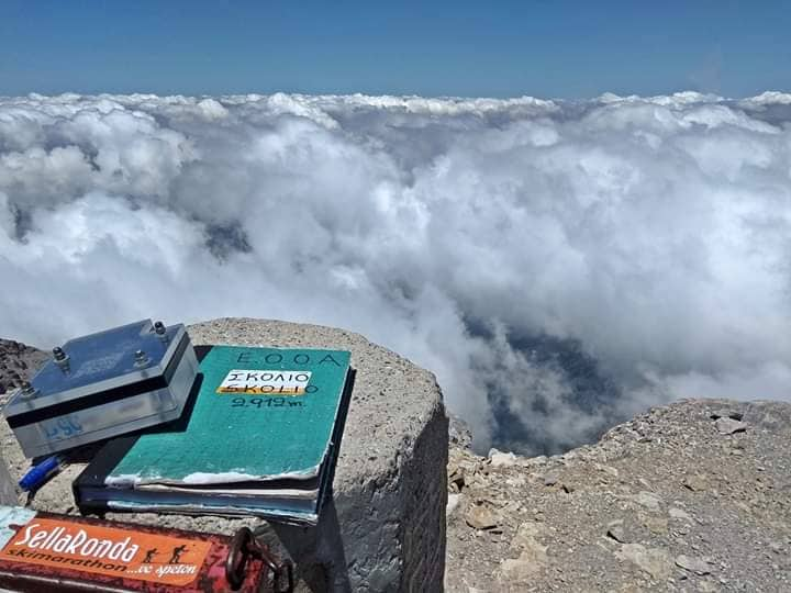
Από τη βάση, ανηφορίζουμε προς την κορυφή και σε περίπου μια ώρα , συνολικά από Αγ, Αντώνιο, πατάμε την κορυφή Σχολιό με υψόμετρο 2.912 μέτρα. Δεν υπάρχουν λόγια για να περιγράψουμε τη θέα από τη δεύτερη ψηλότερη κορυφή του Ολύμπου και της Ελλάδας.

Η επιστροφή γινεται από την ίδια διαδρομή με τη διαφορά ότι παρακάμπτουμε την κορυφή του Αγίου Αντωνίου, βγαίνουμε στη ράχη του καταφυγίου «Κώστας Μιγκοτζίδης» και πίσω στο ΚΕΟΑΧ.
Μια υπέροχη και γρήγορη διαδρομή για το Σχολιό που δεν έχει την ομορφιά του δάσους, αλλά τη μεγαλοπρέπεια και την αγριάδα του αλπικού τοπίου που μας χαρίζει ο Όλυμπος , η κατοικία των θεών.