Pieria Mountains are located northwest of Olympus. It is a much wooded mountain that stretches in three prefectures. The prefectures of Pieria, Kozani and Imathia. Although it is over two thousands meters (highest peak is Flambouro 2188m), its comparison with its large neighbor, Olympus, makes it seem small. So it does not impress with its height but with its beautiful paths and the tranquility of the landscape. According to Greek mythology the nine Pierides Muses are the daughters of Pieros and Evippi and protectors and goddesses of the Arts. They were so thrilled by the nature of the mountain that they remained forever there singing their melodic songs for the gods of Olympus.
This is the mountain we wanted to conquer and specifically the summit of Arvanitis, its fourth tallest peak.
USEFUL INFORMATION
Distance from Thessaloniki: 104 km
Toll rates, one way (Egnatia odos and Aegean motorway) 3,30 Euro
European Emergency Number: 112
Fire Brigade Dept: 199
Medical Emergency: 166
Elatochori ski center – Arvanitis summit (Alt. 2023m)
Route Information
Route Description: Hiking, Trekking
Route Length: 12,9 km
Water in route: Yes
Duration: 2h and 56 min (ascent) / 1h and 45 min (descent)
The route took place at JUN 2021
Team members: 9 adults
We started from Thessaloniki to Elatochori and its ski resort, located in the Prefecture of Pieria. From that point starts the route to the summit. We leave our cars in the parking lot of the ski center and we follow the earth road that passes from the back of the chalet. In about 20 meters we turn left, East, cutting vertically the ski track. The earth road continues to climb lightly, from the opposite side of Chalet and the ski track is now on our right hand. Initially it moves East and then turns in a “general” South direction, derogating for a little while Southeast and later it continues in a steady South – Southwest direction.
Attention, stay on the forest road and do not deviate to the crossing paths because either you will find yourself onto the ski track where you will have to continue climbing in high incline, or you will get down deep in the forest, quite far from the summit route.

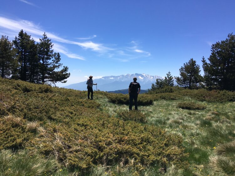
We hike for several kilometers on the forest road through the beautiful forests of the mountain. Forests which are rich and overgrown with oaks, beeches, chestnuts at the beginning and fir and black pines as we continue our ascent, while rare species of wildflowers are forming a carpet for our feet. The view is excellent. To the South, Olympus Mountain and to the East Thermaikos Gulf, are with us throughout the route. Their view is playing hide and seek with the trees that allows us sometime to see them clearly and sometimes not. In our route we also meet two fountains and so we do not have to worry about water.
The incline of the forest road is mild and we are gaining altitude slowly, without getting particularly tired. At the end of the last ski lift we have two choices, the first is to continue on the forest road and get to the plateau below the summit and the other is, by taking a shortcut, to follow the uphill direction to the ridge over the ski lift and get again to the plateau. From the plateau, we continue to hike slightly uphill for about 2 km. We are hiking now on a well-formed path, between low vegetation and wildflowers, which takes us in a small col.

In front of us, we see the south side of Pieria and the magnificent Olympus in the Southeast. On our right, far in the Southwest, we can see the summits of “Lapousi” and “Flambouro” and on our left, in the East, the outskirts of a small spruce’s forest.

The path enters the forest and in five minutes we are coming out of it, reaching the small plateau of the summit. We see the wooden sign writing “Thoma Rachi – Arvanitis” that marks the end of the route and we climb the last few rocky meters to the summit. All the things we are writing here cannot describe the majestic view from the 2023m of altitude. To the South, Olympus Mountain with its great splendor, to the East Thermaikos gulf with Chortiatis Mountain and Thessaloniki, to the North Vermio Mountain and the lake of Polifitos, to the West, the Plateau of Kozani with the view going up to Ptolemaida and Askio Mountain. We were standing there, astonished by the view, wishing to stay there forever. For a moment we had the idea to step on “Flambouro” summit but we needed another two and half hours and we hadn’t so much time.

After the photos and the videos, we took the way back, again, from the same path to the first Plateau, the one bellow the summit. Then we followed the forest road (we did not take the ridge path) and when we met the first ski lift we started to descend from the ski slopes. The incline is not to steep but it was hard, good for skiers, but demanding for the knees of the hiker. We are hiking down freely, admiring Vermio Mountain and Polifitos Lake, which are getting closer and closer as we descend. Step by step we are getting closer to our starting point, the chalet, in which we arrived in about an hour and forty-five minutes.
We had a little stop for rest, and gear tidying and after that, straight to Elatochori for the usual “and of route” feast. In the village square in “Takos” tavern under a large plane tree, we ate well and cheap and we highly recommend the place. Telling old mountaineering stories and designing the new trekking mission, the time passed quickly and delightfully. Late afternoon, physically tired but spiritually restful and mentally complete, we left behind us Pieria Mountains and the song of the Muses and we took the way back to Thessaloniki.